Tarapur Fm
Type Locality and Naming
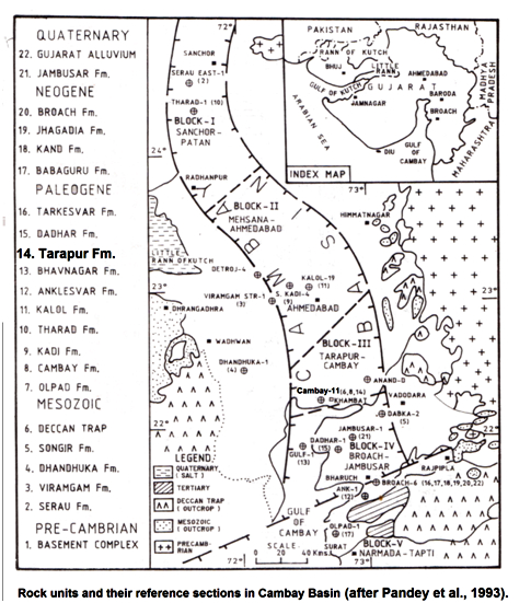
SUBSURFACE: Well Cambay-11 (depth interval 1390-1745 m), 455 m thickness. [Original Publication: Zobov, I.P., Nagolny, I.K., Zapivalov, N.P. and Chandra, P.K. (1966) Problem of correlation and distribution of hydrocarbon bearing horizons in the Eocene of Cambay Basin, ONGC Bull, vol 3 (2), pp. 9-13.]. Reference well: i) Limbodra-1 (depth interval 653 – 758 m); ii) South Dholasan-1 (depth interval 999 – 1118 m); iii) Delwada-1 (depth interval 1256 – 1359 m), In Limbodra-1 the thickness is 105 m while in South Dholasan-1 and Delwada-1 the thickness is 119 m and 103 m, respectively.
Synonyms: Tarapur Shale
Lithology and Thickness
Claystone. In type section, the formation consists of greenish-grey at places, dark grey, poorly fissile, silty and sandy shales, with occasional presence of sideritic bands in the lower part and argillaceous sandstone, siltstone, calcareous, grey shales in the upper part. In the reference section, along the eastern margin, the formation is characterized by grey, sandy shales. In the middle part, oolitic and chamositic claystones and sands / silts are developed. In South Dholasan-1 and Delwada-1, the shales are often pyritic, highly fossiliferous laminated and occasionally calcareous.
In type section 355m, in Lambodra-1 it is 59 m. Maximum thickness recorded at Tarapur-Cambay block in the range of 300-400 m.
[Figure 1: Rock units and their reference sections in Cambay Basin (after Pandey et al., 1993)]
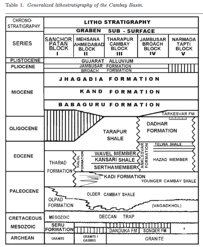
[Figure 2: Generalized stratigraphy of the Cambay Basin. (from Jaiswal and Bhattacharya, 2018, J.EarthSyst.Sci., 127:65)]
Relationships and Distribution
Lower contact
Conformable with the Kalol Fm in Tarapur- Cambay and Mehsana - Ahmedabad blocks.
Upper contact
Unconformable with the Babaguru Fm.
Regional extent
The formation is extensive throughout the North Cambay Basin subsurface. However, in South Cambay Basin, upper part of Tarapur Shale is equivalent to the formation developed as Dadhar Fm. In the extreme south where Anklesvar Fm shales out in Hazira, Dumas and Mindola areas equivalent Tarapur Shale is developed, which of course was earlier considered as Hazira Shale (upper part).
GeoJSON
Fossils
The larger foraminifers are represented by Nummulites acutus, N. djodjokartae, N. maculates, N. fabianii, N. beaumonti, N. stamineus, N. uranensis, Discocyclina, Dispansa, Discocyclina sp., Propocyclina sp., Asterocyclina, Dictyoconoides cooki, and Chilogumbelina martini. Planktic foraminifera include Globigerina eocaena, G. yeguaensis, G. linaparta, Turborotalia cerroazulensis, Globigerina.
Age
Depositional setting
Additional Information

